Aggiungi mappa
Come società organizzatrice, ci sono due tipologie di mappe disponibili:
- Mappe caricate direttamente su Livelox
- Mappe della Federazione Svedese di Orienteering Omaps
Livelox supporta varie mappe per evento, è particolarmente utile nel caso di di percorsi a staffetta dove varie frazioni usano aree diverse. Una categoria/staffetta però può essere collegata ad una sola mappa.
Mappe direttamente da Livelox
Se la mappa è utilizzata per un evento su Livelox, può essere caricata direttamente su Livelox. Si possono caricare mappe in formate immagine (per esempio PNG o TIFF) o in formato mappa digitale (per esempio OCAD o Open Orienteering Mapper).
La mappa dev’essere georiferita, nel caso non lo sia è possibile utilizzare lo strumento di collimazione con l’immagine satellitare. I file immagine per mappe caricate direttamente su Livelox sono creati come descritto nellaguida di Omaps. Nota! il percorso non dev’essere incluso nel file della mappa, dev’essere inserito separatamente. Separare la mappa e il percorso permette di utilizzare la stessa mappa per categorie diverse all’interno dell’evento.
Mappe da Omaps
Le mappe possono essere utilizzate da società e membri della Federazione Svedese di Orienteering. Le informazioni su come utilizzare Omaps in Livelox sono in inglese: Maps can be uploaded as picture files in the Swedish Orienteering Federation's map database Omaps. When you have logged into Livelox, click onManage-the link at the top of the page and choose Maps. You are transferred over to Omaps in the inlogged mode. Click again on Manage and choose Maps.
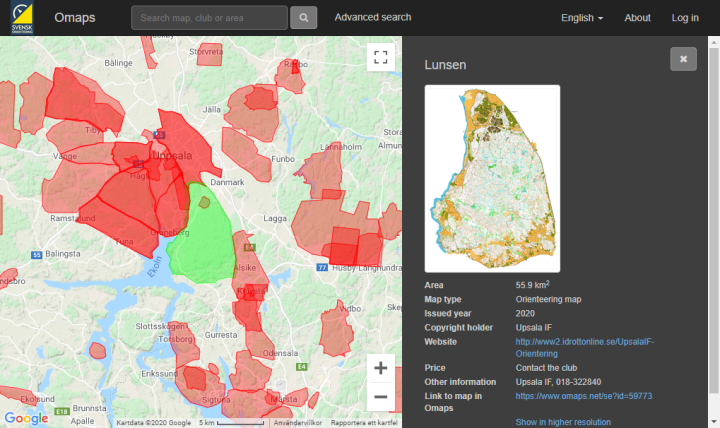
Note that the maps should be loaded in without any form or graphic elements such as map name, border, club logos or something similar. The course should not be in included in the map, and should instead be uploaded separately. By separating the map and the course the sam map can be used over and over again, and you use less time uploading maps.
Omaps requires that the maps that are loaded into the database system are georeferenced. Georeferenced means that the longitude and latitude for the map corners are known. Maps have been created in recent years are most likely georeferenced. The reference system that is the most common for orienteering maps in Sweden is SWEREF 99 TM. Coordinates for flags that sit on the roof of Stockholm's castle in SWEREF 99 TM are N 6580486, E 674763. A unit in SWEREF 99 TM is equivalent to one meter in reality.
If you have a map that is not georeferenced you can reference it simply in conjunction with uploading it. You do this by marking two points in the uploaded map and the related two points in the satellite picture.
Maps that are loaded into Omaps can be shared with other services than Livelox. For every service it is possible to choose which resolution the maps should be shared with. For good quality, Livelox recommends that traditional maps are provided in a resolution of 0.75 pixels per meter. That corresponds to 286 DPI (dots per inch) for a map with scale 1:15 000. For sprint maps, we recommend 2.5 pixels per meter. That corresponds to 254 DPI for a map in the scale 1:4000. Keep in mind that a map in high resolution takes a longer time to load and might make the playback unsmooth, so do not upload excessively high-resolution maps.
For information about exporting of picture files in the most common map drawing program OCAD and uploading of picture files to Omaps refer to the help page of Omaps.
 Our new, future-proof tracking model delivers even better precision and battery life. The obvious choice for live tracking - order it directly from the online store.