Add maps
As an event organizer, when you work with your event in Livelox you can use three types of maps:
- Maps uploaded directly in Livelox
- Maps from the Swedish Orienteering Federation's map service Omaps (only when logged in with an Eventor account)
- Maps from WMTS sources
Livelox supports multiple maps per event. It is useful when different classes or relay legs use different areas. However, a class can only be linked to a single map.
Maps from Livelox
If the map is only going to be used for one event in Livelox it can be uploaded directly to Livelox. This is convenient if the map is manipulated in some way, for example a contour line map or corridor map that there is no point in inserting into Omaps. Both image files (e.g. in PNG or TIFF format) and map files (in OCAD or Open Orienteering Mapper format) can be uploaded.
The map needs to be georeferenced. If it isn't, it can easily be done by fitting it onto a satellite image. Image files for maps that are uploaded directly into Livelox are created in the same way as described on the help page for Omaps. Note that the course should normally not be included in the map image file, but should be uploaded separately. By separating the map and course, the same map can be used for all classes in the event, and start, controls and finish are aligned by their coordinates.
Maps from Omaps
Maps can be uploaded as picture files in the Swedish Orienteering Federation's map database Omaps. When you have logged into Livelox, click onManage-the link at the top of the page and choose Maps. You are transferred over to Omaps in the inlogged mode. Click again on Manage and choose Maps.
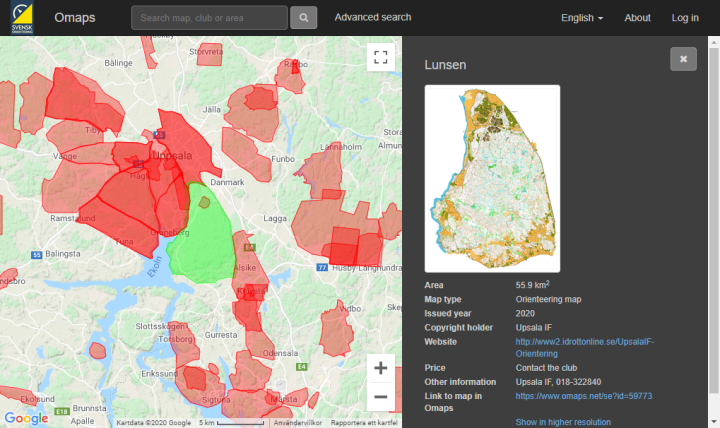
Note that the maps should be loaded in without any form or graphic elements such as map name, border, club logos or something similar. The course should not be in included in the map, and should instead be uploaded separately. By separating the map and the course the sam map can be used over and over again, and you use less time uploading maps.
Omaps requires that the maps that are loaded into the database system are georeferenced. Georeferenced means that the longitude and latitude for the map corners are known. Maps have been created in recent years are most likely georeferenced. The reference system that is the most common for orienteering maps in Sweden is SWEREF 99 TM. Coordinates for flags that sit on the roof of Stockholm's castle in SWEREF 99 TM are N 6580486, E 674763. A unit in SWEREF 99 TM is equivalent to one meter in reality.
If you have a map that is not georeferenced you can reference it simply in conjunction with uploading it. You do this by marking two points in the uploaded map and the related two points in the satellite picture.
Maps that are loaded into Omaps can be shared with other services than Livelox. For every service it is possible to choose which resolution the maps should be shared with. For good quality, Livelox recommends that traditional maps are provided in a resolution of 0.75 pixels per meter. That corresponds to 286 DPI (dots per inch) for a map with scale 1:15 000. For sprint maps, we recommend 2.5 pixels per meter. That corresponds to 254 DPI for a map in the scale 1:4000. Keep in mind that a map in high resolution takes a longer time to load and might make the playback unsmooth, so do not upload excessively high-resolution maps.
For information about exporting of picture files in the most common map drawing program OCAD and uploading of picture files to Omaps refer to the help page of Omaps.
Maps from WMTS
Any map on the Internet provided as WMTS (Web Map Tile Service) can also be used. Livelox comes with built-in support for a few MapAnt instances, as well as Open Street Map. You can also add a custom WMTS address, which opens up for endless opportunities. WMTS maps are mostly used in non-orienteering scenarios.
 Our new, future-proof tracking model delivers even better precision and battery life. The obvious choice for live tracking - order it directly from the online store.